Hazardous Weather Outlook
National Weather Service Milwaukee/Sullivan WI
350 AM CDT Sun Aug 9 2020
WIZ046-047-051-052-056>060-062>072-100900-
Marquette-Green Lake-Fond du Lac-Sheboygan-Sauk-Columbia-Dodge- Washington-Ozaukee-Iowa-Dane-Jefferson-Waukesha-Milwaukee-
Lafayette-Green-Rock-Walworth-Racine-Kenosha-
350 AM CDT Sun Aug 9 2020
This Hazardous Weather Outlook is for portions of east central Wisconsin, south central Wisconsin and southeast Wisconsin.
.DAY ONE...Today and Tonight
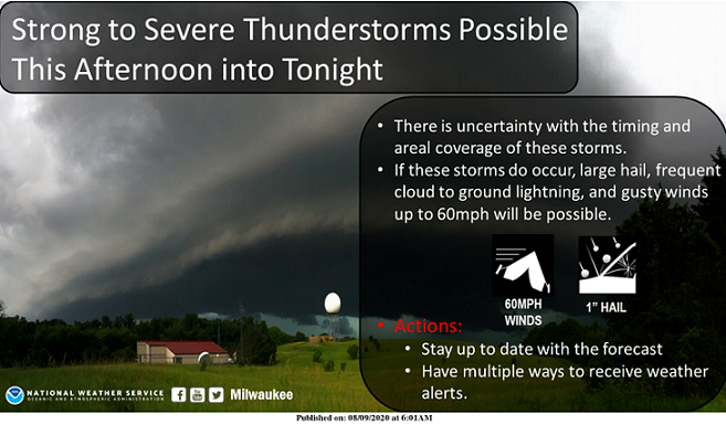
Chances for thunderstorms are forecast later this afternoon into tonight. There is uncertainty with the timing and coverage of
storms across the area during this period.
If storms can develop and move into the area, strong to severe storms are possible. Large hail to one inch in diameter, damaging
winds to 60 MPH, locally heavy rainfall and frequent cloud to ground lightning are possible.
Heat index values will be in the middle 90s today.
.DAYS TWO THROUGH SEVEN...Monday through Saturday
Chances for thunderstorms linger into Monday, as a cold front moves southeast through the region. There is uncertainty again
with the coverage of storms across the area Monday.
If storms can develop, a few strong to severe storms are possible, mainly along and south of a Mineral Point, to Madison, to Milwaukee line. Large hail to one inch in diameter, damaging winds to 60 MPH, and frequent cloud to ground lightning are possible.
Heat index values may reach the middle 90s on Monday in southeastern parts of the area.
There are mainly small chances for thunderstorms at times Wednesday through Saturday.
.SPOTTER INFORMATION STATEMENT...
Spotter activation may be needed at times this afternoon into Monday.
$$