Apr. 14, 2026 8:50a; Updated at 12:30p
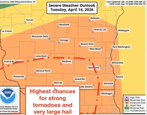
(WGTD)---The National Weather Service says another round of severe weather is expected today across southern Wisconsin, including the WGTD listening area. And this activity could be a bit more widespread and severe than what moved through Monday night and early Tuesday morning.
Long-track tornadoes, large hail and heavy downpours are all possible, with peak activity well before midnight. NWS, however, says Racine and Kenosha counties could be spared the brunt of the storms, although the area is still in the danger zone.
Storms moved through southeast Wisconsin in the early morning hours of Tuesday, triggering numerous thunderstorm and tornado warnings, including a tornado warning that covered all of Racine County for a time. While rotation was indicated on the radar numerous times overnight, there were no reports of any touchdowns, save for a tornado north of Eau Claire.
Winds due to the storms overnight were in the 60 to 70 miles per hour range. Numerous trees and branches were down along with a report of a half-dozen utility poles being damaged at a location west of the interstate in Racine County.
A couple hundred We Energies customers in Racine and Kenosha counties were without power at daybreak. The number in Walworth County was around 2,400.
-0-